
Listen to this Post
Introduction
NASA is intensifying its efforts to better understand earthquakes and land deformation in California through a sophisticated airborne radar campaign involving the agency’s C-20A aircraft. Flying over Central California, the mission aims to collect highly detailed measurements of ground movement along the infamous San Andreas Fault while supporting the groundbreaking NISAR satellite mission developed jointly by NASA and ISRO.
The project represents another major step in Earth observation science, combining airborne technology with satellite-based monitoring systems to create one of the most advanced earthquake tracking efforts ever attempted. Scientists hope the data will improve earthquake forecasting models, refine radar measurements from space, and provide deeper insight into how Earth’s crust shifts over time.
NASA Expands Earthquake Monitoring Operations
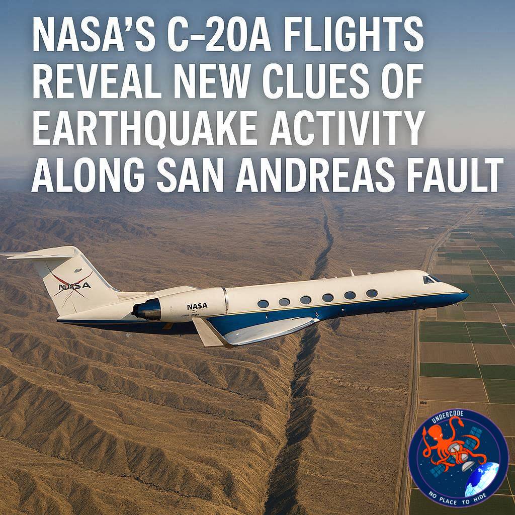
NASA’s C-20A aircraft completed a series of specialized flights on April 29 across Central California as part of a broader scientific campaign focused on earthquake dynamics and land deformation. The flights are designed to gather precise radar data that can help researchers improve the accuracy of earthquake models in one of the most geologically active regions in the United States.
The campaign began on September 30, 2025, and will continue throughout the year to build a longer and more detailed time series of observations. By repeatedly scanning the same regions over time, scientists can detect even tiny movements in Earth’s surface that may indicate tectonic stress or gradual deformation.
Advanced Radar Technology on Board
The aircraft used for the operation is NASA’s C-20A, stationed at Armstrong Flight Research Center in Edwards, California. Mounted aboard the aircraft is the Uninhabited Aerial Vehicle Synthetic Aperture Radar, better known as UAVSAR, a sophisticated radar system developed by NASA’s Jet Propulsion Laboratory in Southern California.
UAVSAR is capable of detecting extremely small changes in Earth’s surface, even down to centimeter-level movements. This makes it especially useful for tracking fault activity, monitoring subsidence, and studying land motion caused by natural or human-related processes.
Unlike conventional imaging systems, synthetic aperture radar can penetrate clouds and operate day or night, giving scientists uninterrupted access to critical geological data.
Supporting the NISAR Satellite Mission
The recent flights were carefully coordinated with the orbit of the NISAR satellite mission, a collaborative project between NASA and the Indian Space Research Organisation (ISRO). NISAR was launched last year to observe Earth’s changing landscapes and monitor hazards across the planet.
The mission is designed to track earthquakes, volcanic activity, glacier movement, ecosystem changes, agricultural conditions, and shifting ice sheets. Using advanced radar imaging, NISAR can scan nearly all of Earth’s land and ice surfaces twice every 12 days.
By flying UAVSAR along the same paths observed by NISAR, researchers can compare airborne and satellite data to calibrate measurements more accurately. This process helps scientists better understand how atmospheric conditions influence radar observations from space.
Measuring the San Andreas Fault
One of the key objectives of the flights was measuring crustal deformation along the San Andreas Fault, one of the world’s most studied fault systems. The fault marks the boundary between the Pacific and North American tectonic plates and has produced some of California’s most devastating earthquakes.
Using UAVSAR, scientists recorded subtle ground motion linked to tectonic stress accumulation. These movements may appear insignificant on the surface, but they can reveal valuable information about how strain builds up underground before seismic events occur.
Repeated observations over time allow researchers to create more accurate deformation maps, helping scientists identify areas where geological stress may be increasing.
Monitoring Groundwater-Driven Subsidence
Beyond earthquake research, the mission also mapped land subsidence across California’s Central Valley. Subsidence occurs when the ground sinks due to excessive groundwater extraction, a growing concern in drought-prone agricultural regions.
As groundwater is removed faster than it can naturally recharge, underground sediment layers compress, causing the surface above to sink. This process can damage roads, canals, pipelines, and buildings while permanently reducing groundwater storage capacity.
NASA’s radar observations help local authorities and environmental scientists better understand how water usage is reshaping the landscape.
Six-Month Calibration Campaign
The flights are part of a six-month calibration and validation campaign designed to ensure NISAR’s radar systems are producing highly accurate measurements. Calibration is critical because even minor atmospheric interference can affect radar readings collected from orbit.
By comparing airborne UAVSAR measurements with satellite observations, researchers can fine-tune NISAR’s instruments and improve long-term reliability. The campaign also helps validate scientific models used to interpret radar data worldwide.
This collaboration between airborne and satellite systems creates a powerful multi-layered approach to Earth monitoring that was impossible only a decade ago.
What Undercode Say:
Earthquake Science Is Entering a New Era
NASA’s latest airborne campaign demonstrates how earthquake monitoring is shifting from reactive science toward predictive intelligence. Instead of studying only the aftermath of earthquakes, modern radar systems are increasingly focused on identifying subtle geological changes before major seismic activity occurs.
Radar Technology Is Becoming the Core of Planetary Observation
Optical satellites depend heavily on weather conditions and daylight, but radar systems like UAVSAR and NISAR operate continuously regardless of clouds or darkness. This makes radar one of the most reliable tools for long-term environmental monitoring.
The San Andreas Fault Remains a Global Research Priority
The San Andreas Fault is not simply a California issue. It serves as a global natural laboratory for understanding tectonic mechanics that can apply to other fault systems around the world. Data collected here may eventually improve earthquake preparedness strategies in Asia, South America, and Europe.
NISAR Could Transform Climate and Disaster Research
Although earthquake science is a major focus, NISAR’s applications extend far beyond tectonics. The satellite will provide valuable insights into glacier retreat, forest degradation, coastal erosion, and agricultural changes driven by climate shifts.
Groundwater Depletion Is Becoming a Hidden Geological Threat
The inclusion of subsidence mapping in this campaign highlights how human activity is now influencing geological stability. Excessive groundwater extraction does not only create environmental problems; it physically changes the structure of the land itself.
International Collaboration Is Accelerating Space Science
The NASA-ISRO partnership behind NISAR reflects a growing trend in global scientific cooperation. Large-scale Earth observation missions are becoming too complex and expensive for single agencies to handle alone.
Continuous Monitoring Matters More Than Single Observations
The decision to conduct repeated flights throughout the year is especially important. Earth deformation is a slow and dynamic process. Long-term datasets often reveal patterns that isolated measurements cannot detect.
Future Earthquake Forecasting May Depend on AI
As radar datasets grow larger, artificial intelligence will likely become essential for identifying hidden seismic patterns. Machine learning systems could eventually analyze crustal deformation data in real time to detect early warning signals.
Infrastructure Planning Could Benefit Greatly
Accurate subsidence and fault movement maps are not useful only for scientists. Urban planners, transportation agencies, and water management authorities can use this information to reduce infrastructure risks in vulnerable regions.
Space-Based Hazard Monitoring Is Becoming Permanent
Missions like NISAR signal the beginning of continuous planetary surveillance for natural hazards. In the future, Earth may be monitored constantly by interconnected networks of satellites, aircraft, and autonomous sensors.
The Data Could Reshape Insurance and Risk Models
More precise ground movement data may eventually influence insurance industries and disaster preparedness policies. Regions previously considered low-risk could be reevaluated based on long-term deformation patterns.
California Remains a Critical Testing Ground
California’s combination of tectonic activity, drought conditions, and dense infrastructure makes it one of the most important locations for environmental monitoring technologies.
The Scientific Value Extends Decades Into the Future
The data collected today may continue to provide scientific value for decades. Historical deformation records often become crucial when studying future earthquakes or climate-related geological changes.
Small Surface Changes Can Signal Major Underground Processes
One of the most fascinating aspects of radar science is that microscopic surface shifts can reveal massive tectonic forces operating deep underground. Tiny measurements may ultimately help scientists understand enormous geological events.
Earth Observation Is Becoming Increasingly Precise
Modern radar systems can now detect movements smaller than a few centimeters across vast regions. This level of precision is transforming geology into a far more data-driven science than ever before.
Fact Checker Results
✅ NASA’s C-20A aircraft conducted flights over Central California to support earthquake research and NISAR calibration.
✅ UAVSAR was used to measure crustal deformation along the San Andreas Fault and monitor land subsidence in the Central Valley.
✅ The NISAR mission is a joint collaboration between NASA and ISRO focused on monitoring Earth’s changing surface and natural hazards.
Prediction
🔮 NISAR and UAVSAR data will likely become part of future AI-powered earthquake forecasting systems capable of detecting long-term seismic trends earlier than current methods.
🔮 Governments may increasingly rely on satellite-based deformation monitoring to manage water resources, infrastructure safety, and disaster preparedness strategies.
🔮 Continuous radar observation missions could eventually create a near real-time global geological monitoring network for earthquakes, volcanic activity, and climate-driven land changes.
🕵️📝Let’s dive deep and fact‑check.
References:
Reported By: science.nasa.gov
Extra Source Hub (Possible Sources for article):
https://www.discord.com
Wikipedia
OpenAi & Undercode AI
Image Source:
Unsplash
Undercode AI DI v2
Bing
🔐JOIN OUR CYBER WORLD [ CVE News • HackMonitor • UndercodeNews ]
📢 Follow UndercodeNews & Stay Tuned:
𝕏 formerly Twitter 🐦 | @ Threads | 🔗 Linkedin | 🦋BlueSky | 🐘Mastodon


