
Listen to this Post
A Dangerous Spring Awakens Across Alaska
After enduring one of the coldest winters and early spring seasons in recent memory, many communities across Alaska are finally beginning to thaw. While rising temperatures may sound like welcome relief after months of deep freeze, the melting season has introduced another major danger: powerful river flooding caused by breaking ice.
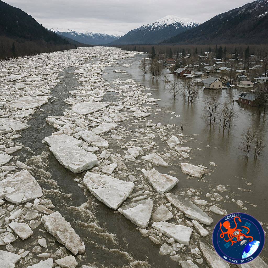
Nowhere is this threat more visible than along the Kuskokwim River, where enormous sheets of river ice have begun cracking, shifting, and jamming as spring temperatures rapidly rise. These ice jams can block flowing water within minutes, forcing rivers to overflow into nearby towns, roads, homes, and businesses.
Satellite images captured by Landsat 9 revealed dramatic changes between late April and early May 2026. What looked like a completely frozen river system only weeks earlier quickly transformed into a chaotic landscape of moving ice, rising water, and flood alerts.
The situation around the town of Aniak became especially concerning as thick ice jams formed both upstream and downstream, triggering flood watches and causing water to spill into vulnerable low-lying neighborhoods.
Scientists and forecasters warn that the conditions seen this year are consistent with what experts call a “dynamic breakup,” one of the most dangerous spring flooding scenarios in Arctic regions.
Kuskokwim River Remained Frozen Deep Into Spring
A Landsat 9 satellite image captured on April 21, 2026 showed the Kuskokwim River still heavily frozen across large sections of western Alaska. Ice near the town of Aniak remained unusually thick and was covered with deep snow even by mid-April.
The frozen river also served another critical role during winter: transportation. A seasonal ice road stretched across roughly 350 miles of the river system, connecting isolated villages that depend on frozen travel routes during the colder months.
That ice road officially shut down on April 10 as warming conditions slowly began weakening the frozen surface.
Despite the closure, forecasters already feared that the unusually cold season had created ideal conditions for future flooding. Thick river ice combined with above-average snowpack can become extremely dangerous when temperatures suddenly rise.
This exact scenario began unfolding during the first week of May.
Massive Ice Jam Developed Near Aniak
By May 6, the front edge of the seasonal ice breakup had nearly reached Aniak. Large sheets of grounded ice suddenly became stuck, creating a massive ice jam stretching approximately 21 miles upstream from the town.
The force of the moving ice was powerful enough to push giant chunks several feet high onto riverbanks. Local reports described dramatic scenes as heavy slabs of ice piled along the shoreline while water levels began climbing behind the blockage.
On May 7, the jam temporarily loosened and started drifting downstream. Satellite imagery showed backed-up water beginning to move again after the ice broke free.
But the danger was far from over.
Later that same night, another blockage formed downstream from Aniak, once again trapping flowing water and rapidly raising river levels near the community.
Flood watches were immediately issued on May 8 as water spread into low-lying sections of town. Reports indicated flooding near homes, businesses, and areas close to the east side of the runway.
Fortunately, water levels receded within two days, limiting the long-term damage. However, the event highlighted how quickly river breakup flooding can escalate in Alaska.
Why Spring Ice Breakup Flooding Is So Dangerous
Spring flooding in Alaska operates differently from ordinary rainfall floods seen in many other regions.
During winter, rivers freeze into thick solid surfaces that can remain intact for months. When rapid warming begins, snowmelt from surrounding areas flows into rivers while the ice itself is still largely frozen.
If the ice remains strong enough, flowing water cannot move freely downstream. Instead, the river becomes blocked by giant slabs of ice that pile together and create temporary dams.
This causes water to back up rapidly behind the blockage.
These “dynamic breakups” are especially hazardous because flooding can appear suddenly with very little warning. Entire neighborhoods may become inundated within hours if an ice jam forms near populated areas.
Forecasters noted that spring 2026 carried several warning signs linked to dynamic breakup conditions.
Cold Winter Created Ideal Conditions for Ice Jams
One of the biggest contributors to this year’s flood threat was Alaska’s extremely cold winter and early spring.
Many river systems accumulated thicker-than-normal ice layers, while snowpack levels remained above average across several major drainage basins.
In Bethel, located downstream from Aniak, average temperatures during March were reportedly 14 degrees Fahrenheit below normal. These prolonged freezing conditions helped preserve river ice far later into spring than usual.
When temperatures finally began rising, the transition happened quickly enough to create instability across river systems.
Experts explain that if river ice weakens gradually before major snowmelt arrives, flood risks become lower because water can flow more naturally downstream. But when thick ice remains intact during rapid warming, dangerous ice jams become far more likely.
Although flooding along Alaska’s largest rivers remained relatively moderate through early May, forecasters warned that conditions could still worsen rapidly if additional breakups occur.
Communities Across Alaska Continue Monitoring Conditions
Residents living near Alaska’s river systems are accustomed to seasonal breakup events, but every year brings different risks depending on weather patterns, snowfall, and ice thickness.
Emergency officials continue closely monitoring river conditions throughout western Alaska as spring progresses northward.
Communities like Aniak remain especially vulnerable because rivers serve as both transportation corridors and central parts of local infrastructure. When flooding develops, it can isolate villages, damage roads, threaten runways, and disrupt essential supplies.
Satellite monitoring from NASA and the U.S. Geological Survey has become an important tool for tracking breakup progression in remote regions where ground observations can be limited.
The rapidly changing satellite images from April and May demonstrate how quickly conditions can evolve during Alaska’s short but volatile spring season.
What Undercode Say:
The 2026 Kuskokwim River breakup highlights a larger climate and infrastructure challenge that Arctic communities increasingly face every spring. While warmer temperatures are often associated with gradual seasonal transitions, Arctic systems frequently respond in sudden and violent ways because frozen landscapes store enormous amounts of energy throughout winter.
One important detail in this event is the contrast between prolonged cold and rapid thawing. Many people assume climate warming simply means less ice overall, but in northern regions, extreme seasonal instability can actually increase short-term flood dangers. A colder-than-normal winter followed by abrupt warming creates ideal conditions for dynamic breakup flooding.
This also demonstrates how dependent many Alaskan communities remain on seasonal ice infrastructure. The Kuskokwim ice road served hundreds of miles of villages during winter, functioning almost like a temporary highway system. Once thaw begins, communities transition from relying on ice transport to facing ice-related disasters almost immediately.
The role of satellite monitoring is becoming increasingly critical in remote Arctic environments. Landsat imagery allowed scientists and emergency responders to visually monitor jam formation, river movement, and downstream flooding risks in near real-time. Without satellite support, predicting flood development across isolated regions would be significantly harder.
Another major concern is how unpredictable breakup timing has become in recent years. Traditional seasonal knowledge remains valuable, but changing weather patterns introduce unusual combinations of deep snowpack, delayed thawing, and rapid temperature spikes that can overwhelm historical expectations.
Infrastructure vulnerability is another issue exposed by the flooding near Aniak’s runway and business areas. Small Arctic towns often have limited flood defenses, and even relatively brief flooding events can disrupt transportation, healthcare access, and supply chains.
The event also reveals how interconnected Arctic environmental systems are. Snowpack levels, river temperatures, atmospheric warming, ice thickness, and upstream breakup timing all interact simultaneously. A small change in one area can create cascading effects hundreds of miles downstream.
Interestingly, forecasters noted that severe flooding had remained relatively limited despite strong warning signs. This suggests that river breakup behavior still contains significant unpredictability. Slight variations in ice strength or breakup timing can determine whether a community experiences minor flooding or a major disaster.
From a climate science perspective, events like this are valuable because they provide measurable data about how Arctic hydrological systems respond under extreme seasonal transitions. These observations improve future forecasting models and emergency preparedness planning.
There is also an economic dimension often overlooked in discussions about Arctic flooding. Damage to roads, fuel storage, airports, and supply infrastructure can become extraordinarily expensive in remote regions where repair operations require specialized transportation and short construction windows.
The Kuskokwim breakup also reflects the psychological reality of living in Arctic communities. Residents move rapidly from months of darkness and isolation into a spring season that can suddenly threaten homes and livelihoods. Seasonal transitions in Alaska are not simply weather events; they directly shape survival, mobility, and local economies.
Another noteworthy aspect is how dynamic breakup floods differ from rainfall-driven floods elsewhere in the world. Ice jam flooding can occur incredibly fast and sometimes recede just as quickly once the blockage releases. This makes emergency response more difficult because flood timing is harder to predict.
Long-term adaptation strategies may eventually require redesigned infrastructure placement, elevated structures, stronger flood monitoring networks, and improved evacuation planning for vulnerable communities.
The event also reinforces the importance of scientific collaboration between local observers, meteorologists, satellite agencies, and hydrological experts. Arctic flood forecasting depends heavily on combining real-world community observations with remote sensing technologies.
As spring continues across Alaska, authorities will likely remain on high alert because additional river systems may still experience similar breakup behavior in the coming weeks.
Fact Checker Results
✅ Landsat 9 satellite imagery was used to monitor changing river ice conditions along the Kuskokwim River during spring 2026.
✅ Aniak experienced flood concerns after multiple ice jams formed upstream and downstream during the breakup event.
❌ Severe catastrophic flooding across Alaska had not yet fully developed by early May 2026, though experts warned conditions could worsen quickly.
Prediction
🔮 Arctic spring flooding events will likely become more unpredictable as extreme seasonal temperature swings continue affecting northern river systems.
🔮 Satellite-based monitoring and AI-supported forecasting tools will become increasingly important for protecting remote Alaskan communities from rapid ice jam disasters.
🔮 Future infrastructure planning in Alaska may focus more heavily on flood-resistant transportation systems and reducing dependence on seasonal ice roads.
🕵️📝Let’s dive deep and fact‑check.
References:
Reported By: science.nasa.gov
Extra Source Hub (Possible Sources for article):
https://www.discord.com
Wikipedia
OpenAi & Undercode AI
Image Source:
Unsplash
Undercode AI DI v2
Bing
🔐JOIN OUR CYBER WORLD [ CVE News • HackMonitor • UndercodeNews ]
📢 Follow UndercodeNews & Stay Tuned:
𝕏 formerly Twitter 🐦 | @ Threads | 🔗 Linkedin | 🦋BlueSky | 🐘Mastodon


