
Listen to this Post
Introduction to the Persistent Navigation Crisis in Robotics
Robotics has advanced at an astonishing pace over the last decade. Machines can now assist in surgeries, automate warehouse logistics, inspect critical infrastructure, and even navigate city streets autonomously. Yet behind this technological sophistication lies a surprisingly fragile weakness. Robots sometimes lose track of where they are. This issue, known in robotics research as the kidnapped robot problem, represents one of the most stubborn and technically complex challenges in autonomous navigation. When a robot is suddenly moved, powered off, or introduced into an unfamiliar environment, it can become disoriented, unable to reconcile its internal map with reality. Now, researchers at Miguel Hernández University of Elche in Spain claim they may have developed a breakthrough system capable of helping robots recover from this disorientation using artificial intelligence and advanced 3D scanning technology.
Understanding the Kidnapped Robot Problem in Autonomous Systems
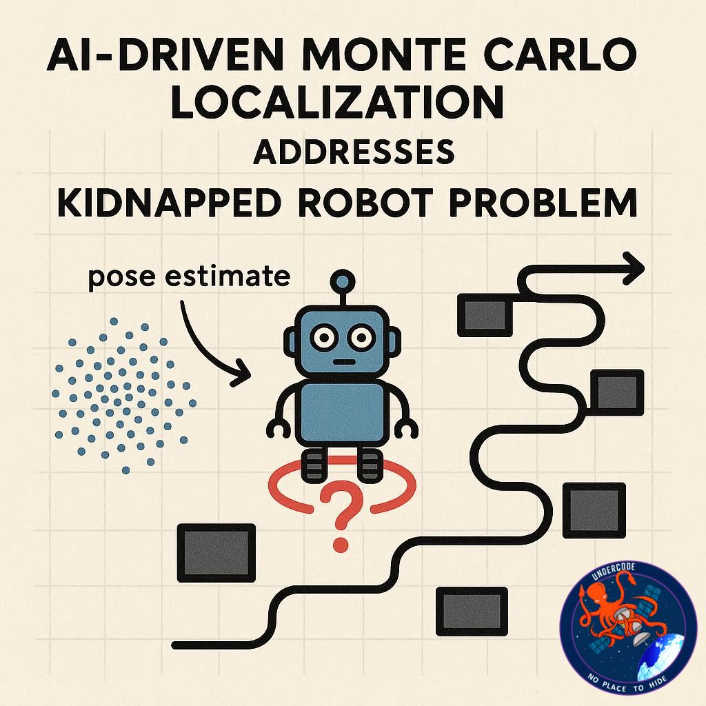
The kidnapped robot problem occurs when a robot’s internal localisation system no longer matches its actual physical position. This can happen during maintenance, after a power interruption, or when a robot is manually relocated. Since many autonomous machines rely on pre-built maps to navigate, even a small unexpected displacement can cause a complete breakdown in navigation logic.
The issue becomes especially problematic in controlled indoor environments such as hospitals, warehouses, factories, and research campuses. Unlike outdoor navigation systems that can often rely on satellite positioning technologies like GPS, indoor systems cannot depend on stable satellite signals. Tall buildings, dense urban layouts, and enclosed facilities weaken or block satellite communication. Without reliable external references, robots must rely on internal sensors and environmental mapping techniques to determine their location.
When those systems fail, the robot does not simply hesitate. It can become entirely uncertain of its position, unable to execute tasks safely or efficiently. For industries investing heavily in automation, this vulnerability limits trust in fully autonomous operations.
The Limitations of Traditional Navigation Technologies
Conventional robotic localisation methods depend on probabilistic algorithms that compare sensor data to stored environmental maps. While effective in stable conditions, these systems struggle when the environment changes. Seasonal shifts, lighting variations, moving objects, and structural modifications can disrupt mapping consistency.
Satellite navigation systems like GPS perform well outdoors, but even there, signal reflections near skyscrapers or signal blockages in dense areas introduce inaccuracies. Indoors, GPS becomes largely ineffective. This forces robots to depend on internal sensors such as cameras, inertial measurement units, and LiDAR scanners.
However, even advanced sensors face difficulty when a robot’s assumed starting point is wrong. If the robot believes it is in one part of a building but is physically somewhere else, every subsequent calculation compounds the error. Recovering from such a state requires a localisation system that can consider multiple possible positions at once and dynamically adjust as new data arrives.
MCL-DLF: A Hybrid AI and 3D LiDAR Localisation Breakthrough
The research team at Miguel Hernández University of Elche developed a system called MCL-DLF, short for Monte Carlo Localisation Deep Local Feature. This approach integrates Monte Carlo localisation techniques with deep learning-based feature recognition and 3D LiDAR scanning.
LiDAR, which stands for Light Detection and Ranging, emits laser pulses to measure distances and generate detailed three-dimensional maps of surroundings. These maps capture both large structures and fine environmental details. The innovation lies in how the system interprets this data.
The process mirrors human spatial reasoning. First, the robot identifies broad environmental features such as building outlines, walls, or clusters of vegetation. Once it determines a general area, it refines its estimation by analysing smaller, distinctive details. This layered recognition system allows the robot to narrow down its exact position with greater precision.
Crucially, the Monte Carlo element enables the robot to maintain multiple simultaneous hypotheses about its possible location. Instead of committing to a single assumption, the system continuously evaluates several potential positions. As new sensor data becomes available, less likely hypotheses are discarded while stronger matches are reinforced. This probabilistic filtering enables real-time correction even after major disorientation events.
Real-World Testing Under Dynamic Environmental Conditions
The research team conducted extensive testing on the university campus over several months. These tests exposed the system to diverse and changing conditions, including variations in lighting, seasonal vegetation growth, and environmental shifts.
The results reportedly demonstrated improved localisation accuracy and greater consistency compared to conventional methods. The system showed resilience when surroundings changed, maintaining reliable performance even when the environmental map differed from earlier recordings.
This real-world validation is significant. Laboratory simulations often fail to capture the unpredictability of real environments. By testing across time and environmental variation, the researchers strengthened the credibility of their approach.
Implications for Healthcare, Logistics, and Autonomous Mobility
Reliable localisation is not a minor technical feature. It is foundational to nearly every practical robotics application. In healthcare, service robots must navigate crowded hospital corridors safely. In logistics, warehouse automation systems depend on precise positioning to manage inventory and optimize routes. Infrastructure inspection robots must accurately map structural elements to detect anomalies. Environmental monitoring systems need dependable spatial awareness to collect meaningful data.
Autonomous vehicles, perhaps the most visible application of robotic navigation, rely on precise localisation to operate safely in complex traffic systems. A vehicle that loses its positional awareness cannot function safely.
If robots can recover from unexpected displacement without human intervention, their operational independence increases dramatically. Reduced downtime, improved safety, and greater reliability would follow. For industries investing billions of dollars in automation, solving the kidnapped robot problem could represent a structural shift in how robotics systems are deployed and trusted.
What Undercode Say:
The kidnapped robot problem is not merely a technical glitch. It exposes a deeper truth about artificial intelligence and autonomy. Robots are often described as independent machines, yet their independence is fragile. The moment environmental certainty disappears, many systems collapse into confusion.
What makes the MCL-DLF approach compelling is not just its algorithmic sophistication. It reflects a philosophical shift in robotic design. Instead of forcing machines to depend on rigid mapping certainty, the system embraces uncertainty as a working condition. Maintaining multiple hypotheses mirrors how humans process unfamiliar spaces. People do not assume absolute certainty when navigating. They continuously revise their understanding based on landmarks, movement, and spatial cues.
This probabilistic resilience may become a defining characteristic of next-generation robotics. As automation expands into dynamic environments such as smart cities, disaster zones, and climate-affected regions, environmental stability cannot be assumed. Robots must adapt to partial information, incomplete data, and shifting conditions.
There is also a strategic economic dimension. Industries are rapidly scaling warehouse automation and autonomous delivery systems. A single navigation failure can halt operations and create cascading delays. Increasing localisation robustness reduces operational risk and strengthens return on investment.
However, this advancement also intensifies competition in AI-driven robotics. Global research centers in Europe, Asia, and North America are racing to enhance spatial intelligence systems. Integration with neural networks, semantic mapping, and predictive modeling will likely follow. MCL-DLF could represent an early layer in a broader architecture of adaptive spatial cognition.
Yet challenges remain. LiDAR systems, while powerful, can be costly and computationally demanding. Scalability will depend on reducing hardware expenses and optimizing processing efficiency. Energy consumption and integration into compact robotic platforms will influence adoption rates.
Another factor is environmental diversity. University campus testing provides variability, but real-world industrial environments introduce more extreme unpredictability. Crowded hospitals, rapidly shifting warehouse layouts, and dense urban corridors each present distinct spatial complexities.
Still, the conceptual breakthrough is undeniable. Robots that can recover from disorientation autonomously mark a step toward genuine operational autonomy. The difference between automation and autonomy lies precisely in this capability. Automation follows instructions within predictable boundaries. Autonomy survives outside them.
In the broader context of artificial intelligence, localisation systems like MCL-DLF contribute to embodied intelligence. Spatial awareness is foundational to intelligent action. Without reliable positioning, higher-level decision-making loses coherence. By reinforcing this foundational layer, robotics moves closer to stable, long-term independence.
The kidnapped robot problem once symbolized a vulnerability in robotic confidence. With AI-driven probabilistic localisation, that vulnerability may soon become a manageable technical hurdle rather than a systemic limitation.
Fact Checker Results
✅ The kidnapped robot problem is a recognized concept in robotics research.
✅ Monte Carlo localisation and LiDAR are established technologies in autonomous navigation.
✅ Indoor environments commonly disrupt GPS-based positioning systems.
Prediction
🚀 AI-enhanced localisation systems will become standard in warehouse automation and healthcare robotics within the next five years.
🤖 Hybrid probabilistic and deep learning navigation models will reduce autonomous system downtime significantly.
🌍 Advanced spatial intelligence will accelerate the deployment of robots in complex urban and industrial environments.
▶️ Related Video (82% Match):
🕵️📝✔️Let’s dive deep and fact‑check.
References:
Reported By: timesofindia.indiatimes.com
Extra Source Hub (Possible Sources for article):
https://www.instagram.com
Wikipedia
OpenAi & Undercode AI
Image Source:
Unsplash
Undercode AI DI v2
Bing
🔐JOIN OUR CYBER WORLD [ CVE News • HackMonitor • UndercodeNews ]
📢 Follow UndercodeNews & Stay Tuned:
𝕏 formerly Twitter 🐦 | @ Threads | 🔗 Linkedin | 🦋BlueSky | 🐘Mastodon


