
Listen to this Post
Introduction: When the Dry Season Turned Into a Disaster
February is typically one of the calmest and driest months in northern Córdoba Department, a period when farmers prepare their land and cattle ranchers rely on receding floodplains to sustain livestock. In early 2026, that predictable seasonal rhythm collapsed. Instead of dry fields and stable rivers, intense and unseasonal rainfall triggered widespread flooding that overwhelmed communities, farmland, and critical infrastructure. Satellite imagery and rainfall data now reveal the scale of an event that quickly escalated into a regional humanitarian crisis.
Seasonal Expectations in Córdoba
For decades, February has been a strategic month for agriculture in Córdoba. Low rainfall allows farmers to till soil and plan planting cycles, while ranchers shift cattle into floodplain pastures as waters usually retreat. This seasonal balance is deeply tied to the local economy and food supply. Any disruption during this window carries outsized consequences for rural livelihoods.
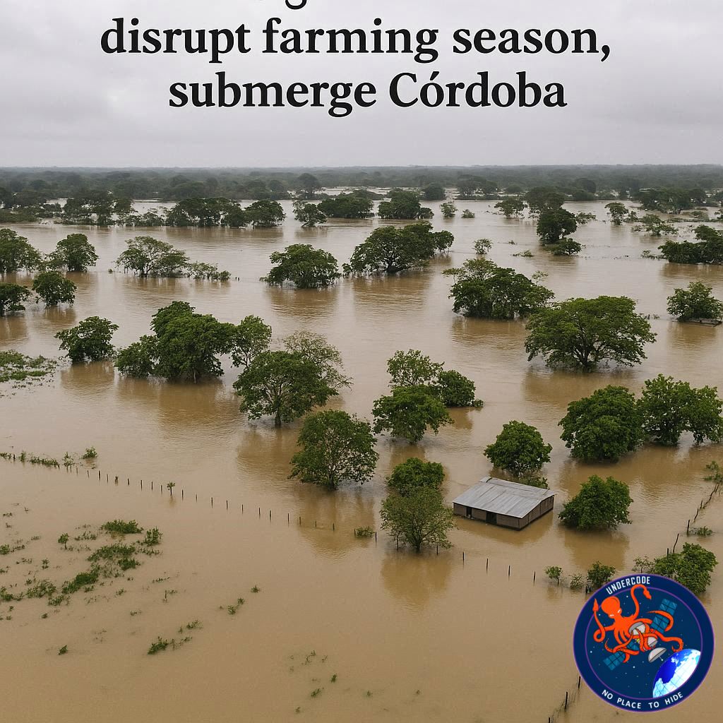
Satellite Eyes on the Flooded Sinú River
On February 9, 2026, the Operational Land Imager aboard Landsat 9 captured striking false color images of flooding along the Sinú River. Dark floodwaters spread across farmland, pastureland, and residential areas, especially west of the river. Eastward, a complex of wetlands showed water levels far above seasonal norms. The contrast with imagery from January 23, just weeks earlier, highlighted how abruptly conditions changed.
Lorica Under Water Pressure
In the northern portion of the imagery, the city of Lorica, home to around 90,000 residents, stood dangerously close to expanding flood zones. Normally buffered by predictable river behavior, Lorica instead faced persistent inundation that threatened housing, roads, and public services. The city became a visual marker of how urban centers were caught off guard by rural scale flooding.
The Meteorological Trigger Behind the Floods
The flooding did not occur in isolation. January 2026 was already wetter than average, saturating soils across Córdoba. The situation worsened on February 1 and 2 when an unusual cold front pushed southward from the Caribbean. This system forced moisture heavy air into northern Colombia and over the Andes, creating ideal conditions for prolonged and intense rainfall.
Rainfall Intensity Beyond Normal Limits
Analyses of the event indicate that some areas of Córdoba received between 4 and 7 centimeters of rain per day during the peak of the storm. According to data from NASA IMERG precipitation estimates, rainfall near Lorica reached rates of approximately 1.7 centimeters per hour on February 1. These values far exceed what local drainage systems and river channels are designed to handle in February.
Flooding That Refused to Recede
The storms did not end after the first week of February. Rainfall continued intermittently throughout the month, preventing rivers from returning to normal levels. By February 25, imagery from NASA’s Terra satellite confirmed that flooding remained widespread across the department, prolonging displacement and delaying recovery efforts.
Humanitarian Impact Across the Department
The consequences were severe. According to the UN Office for the Coordination of Humanitarian Affairs, more than 80 percent of Córdoba was affected by flooding. Preliminary figures from government and media sources reported thousands of homes destroyed, over 11,000 families displaced, and more than 150,000 hectares of farmland submerged. For a region heavily dependent on agriculture and cattle, these losses represent both immediate hardship and long term economic risk.
What Undercode Say: Climate Signals and Structural Vulnerabilities
The Córdoba floods of February 2026 highlight a growing mismatch between historical climate expectations and present day realities. Events once considered rare are increasingly occurring during periods traditionally seen as low risk. This raises urgent questions about how seasonal planning in agriculture and infrastructure design must evolve.
One critical factor is soil saturation. Heavy rainfall in January primed the landscape for flooding, meaning February storms had nowhere to drain. This cumulative effect is often underestimated in disaster planning, yet it plays a decisive role in flood severity.
Another issue is land use. Expansion of farmland and pasture into flood prone areas has reduced natural buffers that once absorbed excess water. Wetlands east of the Sinú River, now visibly swollen in satellite imagery, serve as reminders of ecosystems that historically regulated flooding but are under increasing pressure.
From a technological standpoint, the event demonstrates the value of satellite based monitoring. Near real time data from Landsat, IMERG, and other systems allowed authorities and humanitarian organizations to assess flood extent even when ground access was limited. However, data alone does not prevent disasters. Translating early warnings into early action remains a major challenge.
There is also a social dimension. Rural communities in Córdoba often lack flood resilient housing and insurance mechanisms. When floods arrive unexpectedly during the dry season, households are less prepared, both financially and logistically. This amplifies displacement and slows recovery.
Looking ahead, adaptive planning is essential. Seasonal calendars used by farmers and ranchers may need revision as climate variability increases. Infrastructure such as levees, drainage canals, and rural roads must be designed for rainfall extremes rather than historical averages. Without these adjustments, events like the February 2026 floods risk becoming a recurring pattern rather than an anomaly.
Fact Checker Results
✅ February is typically one of the driest months in Córdoba, making the flooding unseasonal.
✅ Satellite imagery from Landsat 9 confirmed extensive flooding along the Sinú River.
❌ There is no evidence that flooding fully receded by late February 2026.
Prediction
🌧️ Unseasonal rainfall events in northern Colombia are likely to increase in frequency.
🌾 Agricultural planning calendars in regions like Córdoba will need major adjustments.
🚨 Humanitarian response systems may rely more heavily on satellite data for early warnings.
🕵️📝✔️Let’s dive deep and fact‑check.
References:
Reported By: science.nasa.gov
Extra Source Hub (Possible Sources for article):
https://www.digitaltrends.com
Wikipedia
OpenAi & Undercode AI
Image Source:
Unsplash
Undercode AI DI v2
Bing
🔐JOIN OUR CYBER WORLD [ CVE News • HackMonitor • UndercodeNews ]
📢 Follow UndercodeNews & Stay Tuned:
𝕏 formerly Twitter 🐦 | @ Threads | 🔗 Linkedin | 🦋BlueSky | 🐘Mastodon


