
Listen to this Post
Introduction: A Strange Pattern Emerges
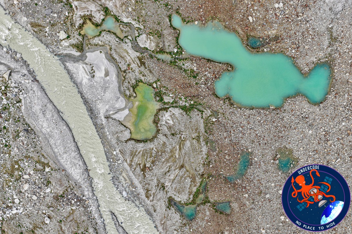
As the Great Salt Lake continues to recede under the pressure of heat and drought, the retreating shoreline has revealed something unexpected. Satellite images now show dozens of small, nearly perfect circles scattered across newly exposed lakebed in Farmington Bay, Ogden Bay, and Bear River Bay. At first glance, they look like odd stains or artifacts. In reality, they are signs of a hidden freshwater system beneath one of the saltiest lakes on Earth—an underground presence scientists did not fully recognize until the lake pulled back enough to expose it.
Summary of the Original
A Discovery Triggered by Falling Water Levels
The mystery began when declining water levels exposed parts of the Great Salt Lake’s playa. In satellite imagery from Landsat and other sensors, researchers noticed clusters of circular features lining the eastern margins of the lake. These features were absent or invisible when water levels were higher, suggesting they were linked directly to the lake’s ongoing shrinkage.
Early Clues from the Water Surface
Years before the playa was exposed, University of Utah researchers traveling by airboat had already noticed something unusual. In certain shallow bays, circular patterns disturbed the water surface, as if something below was pushing upward. At the time, the cause was unclear, and the phenomenon remained unexplained.
Satellite Images Confirm the Pattern
When water levels dropped further, the same circular patterns appeared clearly in satellite images. A comparison between a Landsat 9 image from September 2025 and a Landsat 5 image from September 2011 showed a stark contrast. In 2011, higher water levels concealed the features. By 2025, clusters of circles were fully visible on the exposed lakebed.
Field Expeditions to the Playa
Driven by curiosity, researchers organized field expeditions to investigate these features directly. Access was difficult. To avoid damaging the fragile playa surface, the team avoided vehicles and modern machinery. Instead, they used snow bikes and basic tools, carefully navigating through thick reeds.
Inside the Vegetated “Islands”
At the center of each circular feature, researchers found dense growths of phragmites reeds. These plants formed raised mounds that stood out sharply against the bright, salt-encrusted lakebed. The vegetation itself was the reason the circles appeared so clearly in satellite images.
Measuring What Lies Below
To understand why plants thrived in these spots, the team installed piezometers and other monitoring equipment. They measured groundwater pressure and salinity at different depths and distances from each mound’s center, building a detailed picture of subsurface conditions.
Freshwater Where Salt Was Expected
The results were surprising. Groundwater near the edges of the circles was salty, as expected in a hypersaline environment. But closer to the center, the water was significantly fresher. This freshwater supported plant growth, creating small oases surrounded by barren playa.
A Hidden Freshwater Network
Aerial electromagnetic surveys suggested these features were not rare anomalies. Instead, hundreds of similar groundwater-fed oases likely exist beneath newly exposed areas of the lakebed. Researchers now believe they are connected to an extensive freshwater reservoir hidden below the playa.
Rethinking the Lake’s Water Budget
This discovery has major implications. Analysis suggests that freshwater discharge from these subsurface springs may contribute up to 12 percent of the Great Salt Lake’s total water budget. Before this finding, hydrologists estimated groundwater inflow at roughly 3 percent.
Implications Beyond Curiosity
The presence of direct freshwater inflow into one of the world’s largest salt lakes came as a surprise. While not large enough to serve as a new water supply, this freshwater could play a role in mitigating dust storms by keeping certain areas of the playa moist and vegetated.
Dust, Health, and an Uncertain Future
Great Salt Lake water levels hit a record low in 2022, raising concerns about toxic dust exposure. Dry lakebeds are notorious sources of airborne dust rich in fine sediments and contaminants. While the health impacts are still being studied, researchers agree the risks are real and growing.
Climate and Long-Term Decline
The Great Salt Lake Strike Team attributes the lake’s decline primarily to rising temperatures and consecutive dry years. Human water use compounds the problem, accelerating exposure of the lakebed and amplifying environmental risks across the region.
What Undercode Say:
A Geological Surprise Hidden in Plain Sight
What makes this discovery remarkable is not just the existence of freshwater beneath the playa, but how long it remained unnoticed. The Great Salt Lake has been studied for decades, yet this subsurface system only became visible when the lake reached historic lows.
Shrinking Lakes as Accidental Laboratories
Climate-driven decline often reveals problems, but here it also revealed knowledge. As water recedes, landscapes act like open textbooks, exposing structures that were previously sealed away by depth and salinity.
Freshwater and Saltwater in Delicate Balance
The coexistence of freshwater springs beneath a hypersaline lake challenges simple models of terminal lake hydrology. It suggests layered systems where ancient groundwater pathways still operate despite extreme surface conditions.
Ancient Systems, Modern Consequences
The freshwater reservoir may be artesian and ancient, formed under climatic conditions very different from today’s. Its persistence shows how long geological memory can outlast surface environments.
Revising Hydrological Assumptions
A jump from 3 percent to 12 percent groundwater contribution is not a minor correction. It forces scientists to rethink how water enters, circulates, and leaves the Great Salt Lake system.
Ecological Islands in a Salty Desert
Each vegetated mound functions like a micro-ecosystem. These islands could serve as refuges for insects, birds, and microbes, subtly shaping local biodiversity on the otherwise barren playa.
Satellites as Silent Witnesses
This discovery underscores the value of long-term satellite records. Without decades of Landsat data, the contrast between high-water and low-water conditions might never have been recognized so clearly.
Dust Mitigation as an Unexpected Benefit
While the freshwater is not a solution to water scarcity, its surface expression could slow dust generation. Even small wet or vegetated patches can disrupt wind patterns and reduce sediment lift-off.
Public Health Stakes Are Rising
Toxic dust from drying lakebeds is not theoretical. Similar situations elsewhere have led to increased respiratory illness. Understanding natural moisture sources becomes critical for risk management.
A Warning Signal, Not a Silver Bullet
It is tempting to view hidden freshwater as good news. But it is not a fix for the lake’s decline. Instead, it highlights how much the system is changing—and how complex its responses can be.
Climate Change Makes Discoveries Inevitable
As warming continues, more hidden features will likely emerge across shrinking lakes worldwide. Each discovery will bring insight, but also underscore loss.
Science Catching Up with Change
The pace of environmental change is now fast enough that geology, hydrology, and ecology are being forced to update models in near real time.
Management Must Adapt Quickly
Water managers cannot rely solely on old assumptions. Updated groundwater contributions must be integrated into future planning, conservation, and mitigation strategies.
A Broader Lesson for Terminal Lakes
The Great Salt Lake is not unique. Other terminal lakes may hide similar systems, waiting to be revealed as climate stress intensifies.
Knowledge Born from Crisis
Ultimately, this discovery is both fascinating and unsettling. It shows how much we still do not know—and how environmental decline is often the trigger that finally exposes the truth.
Fact Checker Results
Satellite Evidence Consistency
✅ Multiple Landsat missions confirm the appearance of circular features only after water levels declined.
Groundwater Measurements
✅ Field data supports fresher water at feature centers and higher salinity at the edges.
Water Budget Revision
❌ The 12 percent estimate remains under active study and may change with further modeling.
Prediction
Expanding Scientific Focus 🌍
As lake levels continue to drop, researchers will likely identify even more subsurface freshwater features across the playa.
Policy and Health Implications ⚠️
Dust mitigation strategies may increasingly factor these natural oases into regional health planning.
A New Chapter for Great Salt Lake Science 🔬
The lake will become a key case study for how hidden groundwater systems interact with climate-driven surface collapse.
🕵️📝✔️Let’s dive deep and fact‑check.
References:
Reported By: science.nasa.gov
Extra Source Hub (Possible Sources for article):
https://www.medium.com
Wikipedia
OpenAi & Undercode AI
Image Source:
Unsplash
Undercode AI DI v2
Bing
🔐JOIN OUR CYBER WORLD [ CVE News • HackMonitor • UndercodeNews ]
📢 Follow UndercodeNews & Stay Tuned:
𝕏 formerly Twitter 🐦 | @ Threads | 🔗 Linkedin | 🦋BlueSky | 🐘Mastodon


