
Listen to this Post
Introduction
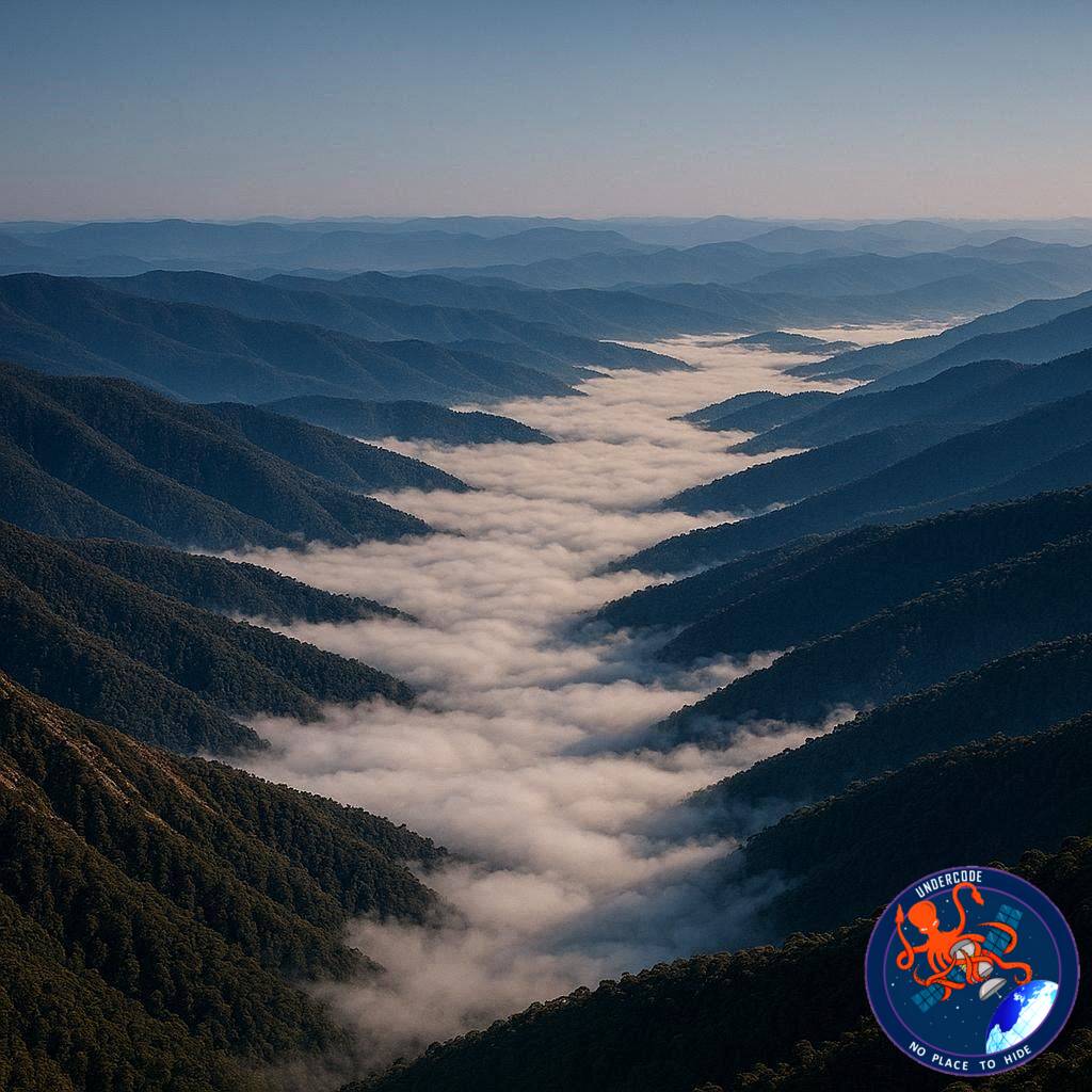
As autumn deepens across the Southern Hemisphere, the mountains of eastern Victoria in Australia transform into a breathtaking natural theater of mist and cloud. In a remarkable satellite image captured by NASA’s Terra satellite, thick morning fog can be seen pouring through valleys like rivers of white silk across the Victorian Alps. The phenomenon is not only visually spectacular, but also scientifically fascinating, revealing how seasonal cooling, geography, and atmospheric conditions work together to create one of nature’s most elegant displays.
The imagery highlights several national parks in the region, where dense fog settled into mountain valleys during the early hours of May. NASA scientists explained that the event was caused by a combination of colder autumn nights, moisture-rich landscapes, calm weather conditions, and the unique terrain of the Alps. The same weather system also produced an unusual arch-shaped cloud over Port Phillip Bay, adding another layer of atmospheric intrigue to the event.
Fog Season Arrives in the Victorian Alps
Autumn in the Southern Hemisphere marks the beginning of fog season in the Victorian Alps. During this time of year, nights become longer, allowing the atmosphere more time to cool. As temperatures approach the dew point, water vapor suspended in the air begins condensing into tiny droplets, creating what meteorologists call radiation fog.
NASA’s Terra satellite captured this extraordinary process as thick blankets of fog filled valleys stretching across eastern Victoria. The fog formed primarily in low-lying areas because cold air naturally sinks downward. Since colder air is denser than warm air, it drains into valleys overnight, making these locations ideal environments for fog development.
The valleys remained covered in mist longer than nearby lowlands because mountain terrain blocks early sunlight. In flatter regions, fog often disappears quickly once the Sun warms the ground. However, shaded mountain valleys can preserve cooler conditions for several additional hours. According to geostationary satellite observations, the fog persisted for nearly two hours after sunrise.
Understanding Radiation Fog
Radiation fog is one of the most common forms of fog, but it requires very specific weather conditions to form properly. Clear skies and calm winds allow heat from the Earth’s surface to escape during the night. As the ground cools, the surrounding air temperature drops until moisture condenses into microscopic droplets suspended near the surface.
Unlike ordinary clouds that float above the ground, fog actually touches the Earth’s surface. This makes visibility drop dramatically while creating the soft, dreamlike appearance visible in satellite imagery.
In this particular case, the Victorian Alps had recently experienced a burst of cold and wet weather. That earlier storm system saturated the soil and vegetation with moisture. Soon afterward, a slow-moving high-pressure system moved into the region, bringing calmer and slightly warmer weather. These stable conditions became the perfect recipe for dense radiation fog.
Rivers and Lakes Intensified the Fog Formation
The geography of the Victorian Alps played a major role in amplifying the event. Many mountain valleys contain rivers, streams, and lakes that continuously release moisture into the surrounding air.
NASA identified several waterways where fog formation became especially pronounced. These included the Mitta Mitta River, Buffalo River, Livingston Creek, Lake Dartmouth, and the Snowy River. The water bodies acted as natural moisture reservoirs, feeding additional water vapor into the already cooling atmosphere.
From space, the fog appeared to trace the shape of these river systems, creating intricate branching patterns through the valleys. The satellite perspective transformed the fog into something resembling glowing white veins stretching through the mountains.
A Rare Arch-Shaped Cloud Over Port Phillip Bay
The fog event was not the only unusual atmospheric feature observed that morning. A few hundred kilometers southwest of the Alps, NASA also captured an unusual arch-shaped cloud formation over Port Phillip Bay.
The cloud stretched across the bay from St. Leonards on the western shore to Mount Eliza on the eastern side. Scientists believe the formation developed because of interacting land and sea breezes combined with the horseshoe-shaped geography surrounding the bay.
As cooler air from land collided with marine air moving inland, the atmosphere created a curved boundary that became visible as an elongated cloud arc. Satellite imagery later showed the cloud slowly drifting southward while the fog in the mountain valleys gradually dissipated.
The event demonstrated how local geography can strongly influence weather patterns even over relatively short distances.
Satellite Technology Reveals Hidden Atmospheric Beauty
Without satellite technology, much of this phenomenon would have gone unnoticed by the wider world. NASA’s Terra satellite, using MODIS imaging data, provided a detailed perspective impossible to achieve from the ground.
Satellite imagery allows meteorologists to track fog movement, observe cloud behavior, and better understand regional climate interactions. These observations are important not only for scientific research, but also for aviation safety, transportation forecasting, agriculture, and environmental monitoring.
The Victorian Alps event also highlights how Earth observation satellites continue revealing the hidden artistry of atmospheric science. What might appear as ordinary fog from ground level becomes an immense and beautifully structured system when viewed from orbit.
The Science Behind Valley Fog Persistence
One of the most interesting aspects of the event was how long the fog remained trapped within the valleys. In mountainous terrain, cold air often becomes confined beneath warmer air above it, creating what meteorologists call a temperature inversion.
Under inversion conditions, cooler air cannot easily rise and disperse. Instead, the fog remains compressed inside valleys until sufficient solar heating breaks the inversion apart. This process explains why valley fog frequently lasts much longer than fog in open plains.
The Victorian Alps provided ideal topographic conditions for this effect. Narrow valleys, moisture-rich landscapes, and reduced morning sunlight combined to sustain the fog well into the early morning hours.
What Undercode Say:
NASA’s observation of the Victorian Alps fog event demonstrates how weather systems are deeply interconnected with geography, seasonal change, and atmospheric physics. While fog may seem like a simple weather occurrence, the event reveals a complex chain reaction involving temperature shifts, moisture transport, terrain-driven airflow, and solar radiation balance.
One particularly interesting aspect is how moisture from previous storms remained trapped in the landscape. Wet soils, rivers, and forests effectively stored atmospheric potential energy in the form of humidity. Once calm conditions arrived, the environment naturally converted that stored moisture into visible fog.
The satellite imagery also highlights how valleys behave like atmospheric containers. Cold air drainage is a powerful process in mountainous environments, and it often creates microclimates very different from surrounding regions. This is why fog can remain thick in valleys while nearby hillsides appear completely clear.
The arch-shaped cloud over Port Phillip Bay adds another scientific layer to the story. Coastal weather interactions are notoriously difficult to model because land and sea temperatures change at different rates. The horseshoe-shaped terrain around the bay likely intensified localized wind convergence, making the cloud boundary visible from space.
Events like this also demonstrate the growing importance of Earth observation satellites. Modern climate science increasingly depends on continuous monitoring systems capable of tracking short-lived atmospheric behavior. Without satellites, transient features such as valley fog evolution or unusual cloud arcs would be difficult to analyze comprehensively.
There is also an ecological dimension to fog that often goes overlooked. Mountain fog contributes moisture to forests, vegetation, and river ecosystems. In some environments, fog can significantly influence biodiversity by moderating temperatures and maintaining humidity levels for sensitive species.
From a climate perspective, studying fog behavior may become increasingly important in future decades. Changes in temperature patterns, rainfall cycles, and atmospheric moisture could alter fog frequency in mountainous regions worldwide. Some studies already suggest that certain regions are experiencing declining fog occurrence due to climate shifts.
The Victorian Alps serve as an excellent natural laboratory for understanding these changes. Their combination of elevation, forests, rivers, and seasonal weather systems creates ideal conditions for observing atmospheric interactions in real time.
Another overlooked factor is the emotional and visual impact of satellite imagery itself. NASA’s images transform ordinary weather into something cinematic and globally accessible. Such imagery plays a major role in public engagement with climate science and atmospheric research.
In many ways, this event is a reminder that Earth’s atmosphere is not static. It is constantly moving, reshaping, cooling, condensing, and interacting with the planet’s surface in highly dynamic ways. Even a quiet autumn morning in Australia can reveal an extraordinary level of atmospheric complexity when viewed from orbit.
The fog formations also emphasize how weather patterns are deeply tied to timing. A slight change in wind speed, cloud cover, or humidity could have prevented the event entirely. Nature often depends on extremely precise balances that produce fleeting moments of beauty and scientific significance.
The visual resemblance between the fog-filled valleys and river systems is especially fascinating. It almost creates a mirror image where waterways on the surface appear echoed by clouds suspended above them. This phenomenon demonstrates how geography directly shapes atmospheric structure.
NASA’s continued monitoring of Earth not only advances meteorology but also preserves remarkable visual records of planetary processes. These images become historical climate references that future scientists may analyze decades from now.
Fact Checker Results
✅ NASA’s Terra satellite did capture fog-filled valleys across the Victorian Alps during May 2026 using MODIS satellite imagery.
✅ Radiation fog forms under calm, clear nighttime conditions when temperatures approach the dew point and moisture condenses near the surface.
✅ The arch-shaped cloud over Port Phillip Bay was likely linked to interacting land and sea breezes shaped by local coastal geography.
Prediction
🔮 Seasonal fog events in mountainous regions like the Victorian Alps will continue attracting scientific attention as climate researchers study changing atmospheric moisture patterns.
🔮 Future satellite systems with higher-resolution sensors may provide even more detailed real-time monitoring of short-lived weather phenomena such as valley fog and coastal cloud arcs.
🔮 Public fascination with Earth imagery from space will likely grow as NASA and other agencies release increasingly cinematic environmental observations from orbit.
🕵️📝Let’s dive deep and fact‑check.
References:
Reported By: science.nasa.gov
Extra Source Hub (Possible Sources for article):
https://www.instagram.com
Wikipedia
OpenAi & Undercode AI
Image Source:
Unsplash
Undercode AI DI v2
Bing
🔐JOIN OUR CYBER WORLD [ CVE News • HackMonitor • UndercodeNews ]
📢 Follow UndercodeNews & Stay Tuned:
𝕏 formerly Twitter 🐦 | @ Threads | 🔗 Linkedin | 🦋BlueSky | 🐘Mastodon


