
Listen to this Post
Introduction: A Winter Event That Redefined the Carolinas
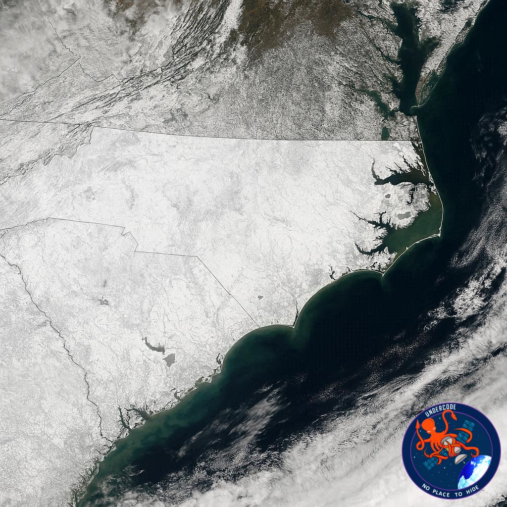
In late January 2026, North Carolina experienced a winter storm that will be remembered for decades. While snow is not unheard of in the state, the scale and reach of this event were exceptional. From the Appalachian Mountains in the west to the Atlantic coastline in the east, snow blanketed every corner of the state. Satellite imagery from NASA offered a striking confirmation: North Carolina appeared almost entirely white, a rare sight even during harsh winters. This storm was not just another cold snap—it was a historic weather event that reshaped expectations of winter across the Southeast.
A Rare Blanket of White Across the Entire State
A NASA Terra satellite image captured on February 2, 2026, revealed an almost continuous layer of snow stretching across North Carolina. According to the North Carolina State Climate Office, measurable snowfall was recorded in all 100 counties, marking the first time in more than ten years that such a statewide event had occurred. This level of coverage is highly unusual for a state that typically sees snow limited to higher elevations or isolated regions.
The Meteorological Setup Behind the Storm
Snowfall in North Carolina usually requires a precise balance of conditions. Cold air must be pulled southward from the north, while moisture arrives from a low-pressure system moving nearby. During the January 31 weekend storm, lingering Arctic air from earlier in the week remained firmly in place. As a storm system tracked close to the coastline, it injected moisture into the cold air mass, creating the perfect environment for widespread snow.
Mountain Regions Hit Hardest
In the western mountains, snowfall totals exceeded one foot in several locations. These accumulations were especially notable after multiple winters with relatively mild conditions and minimal snowfall. Even so, snowfall varied by location, with cities like Asheville seeing lower totals than surrounding higher elevations.
Snow Pushes South Into South Carolina
The storm’s influence did not stop at the state line. Snow spread into parts of South Carolina, including Greenville, located near the foothills of the Blue Ridge Mountains. By the evening of January 31, downtown Greenville had received approximately five inches of snow, according to the National Weather Service, underscoring the storm’s regional impact.
Piedmont Region Sees Historic Totals
Central North Carolina’s Piedmont region also faced significant accumulations. Charlotte recorded nearly a foot of snow, its highest total since 2004. Raleigh experienced a lighter, yet still notable, accumulation of 2.8 inches. These figures reflect how the storm’s intensity varied across the state, influenced by elevation, temperature, and storm dynamics.
Coastal Areas Transformed by Snow and Wind
Perhaps the most surprising scenes emerged along the coast. Beaches normally defined by sand and surf were covered in snow, with parts of Carteret County reporting more than a foot. Beaufort and surrounding mainland communities experienced heavy blowing snow, creating near-whiteout conditions in areas unaccustomed to such weather.
Greenville’s Snowfall Breaks Decades-Old Records
Slightly inland, Greenville recorded 14 inches of snow, a total not seen since a major storm in March 1980. This accumulation placed the city among the hardest-hit locations during the event and reinforced the storm’s classification as historic.
Hazards Hidden Beneath a Beautiful Landscape
From space, the snow-covered state appeared calm and picturesque. On the ground, conditions were far more dangerous. Roads became treacherous, leading to widespread traffic disruptions and numerous vehicle collisions. Major highways, including sections of Interstate 85, were temporarily shut down due to accidents involving dozens of vehicles.
Coastal Damage and Erosion Intensify the Impact
Along the Outer Banks, the storm combined snow with powerful winds and high waves. Ocean overwash flooded sections of Highway 12, leaving water and sand across the roadway. In some areas of Hatteras Island, coastal erosion intensified to the point that several homes collapsed into the ocean, highlighting the storm’s destructive force.
What Undercode Say:
A Sign of Shifting Winter Extremes
This storm stands out not only for its snowfall totals but for its geographic reach. Statewide snow events of this magnitude challenge long-held assumptions about winter weather in the Southeast. North Carolina’s climate typically produces localized snow, making this uniform coverage especially noteworthy.
Satellite Imagery as a Climate Storyteller
NASA’s MODIS imagery played a crucial role in documenting the event. From an analytical perspective, satellite observations provide more than visual confirmation—they allow scientists to study snow extent, albedo changes, and post-storm temperature effects across large regions.
The Role of Arctic Air Persistence
One key takeaway is the importance of lingering cold air. The Arctic air mass remained in place longer than usual, increasing the likelihood that incoming moisture would fall as snow rather than rain. This persistence may signal changing atmospheric patterns that favor longer-lasting cold outbreaks.
Infrastructure Vulnerability in Rare Snow Zones
The widespread disruptions reveal how vulnerable southern infrastructure remains to major winter storms. Roads, coastal defenses, and emergency response systems are often designed for milder conditions, leaving communities exposed when rare extremes occur.
Coastal Risks Beyond Snowfall
The storm demonstrated that winter weather threats along the coast extend beyond snow. High winds, storm surge, and erosion caused damage comparable to tropical systems, suggesting that winter storms deserve equal consideration in coastal planning.
A Reminder of Climate Variability, Not Simplicity
While single events cannot define long-term climate trends, storms like this highlight increasing variability. Extremes—both hot and cold—are becoming more disruptive, demanding better preparedness rather than reliance on historical averages.
Lessons for Emergency Planning and Forecasting
Improved forecasting helped mitigate some impacts, but the scale of disruption shows there is room for improvement. Better public communication, adaptive infrastructure, and region-specific winter response plans could reduce future risks.
Why This Storm Will Be Studied for Years
Meteorologists and climate scientists are likely to analyze this event for decades. Its combination of timing, atmospheric setup, and statewide impact makes it a valuable case study for understanding rare winter extremes in the southeastern United States.
Fact Checker Results
Verification of Key Claims
Statewide snowfall across all 100 counties is confirmed by official climate records. ✅
Snow totals cited align with National Weather Service and state climate office reports. ✅
Coastal damage and road disruptions were widely documented by regional media. ✅
Prediction
What Comes Next for Southern Winters ❄️
Extreme winter events like this are likely to remain rare, but when they occur, they may be more intense and disruptive. As atmospheric patterns grow more volatile, North Carolina and neighboring states should expect greater swings between mild winters and sudden, historic snowstorms. Preparation—not surprise—will define resilience in the years ahead. 🌨️
🕵️📝✔️Let’s dive deep and fact‑check.
References:
Reported By: science.nasa.gov
Extra Source Hub (Possible Sources for article):
https://www.reddit.com
Wikipedia
OpenAi & Undercode AI
Image Source:
Unsplash
Undercode AI DI v2
Bing
🔐JOIN OUR CYBER WORLD [ CVE News • HackMonitor • UndercodeNews ]
📢 Follow UndercodeNews & Stay Tuned:
𝕏 formerly Twitter 🐦 | @ Threads | 🔗 Linkedin | 🦋BlueSky | 🐘Mastodon


