
Listen to this Post
Introduction: A Sudden Turn Toward Danger
March 15, 2026, known historically as the Ides of March, delivered more than symbolism to West Texas and the Panhandle. It unleashed a powerful and fast-moving weather system that transformed calm skies into a hazardous environment within hours. A fierce cold front collided with already dry conditions, triggering violent winds, massive dust clouds, and an alarming spike in wildfire risks. What began as a typical spring weather shift quickly escalated into a multi-layered environmental threat affecting visibility, safety, and entire communities.
A Wall of Dust Sweeps Across Texas
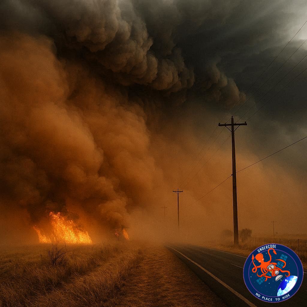
The defining feature of this event was a massive dust plume driven by strong winds across the arid plains of Texas. As the cold front surged southward, it lifted loose soil into the air, forming a thick curtain of dust that spread rapidly across the region. Visibility dropped sharply, turning highways into dangerous corridors where drivers struggled to see even a few meters ahead.
Satellite Imagery Captures the Scale
Images from NASA provided a dramatic perspective of the storm’s scale. The MODIS instrument aboard the Aqua satellite recorded the dust cloud advancing across Texas in the late afternoon. Earlier imagery from the Terra satellite showed the same plume further northeast, highlighting how quickly the system moved. These visuals confirmed the sheer size and intensity of the dust storm as it expanded across hundreds of kilometers.
Ground-Level Chaos and Near-Zero Visibility
On the ground, the situation became increasingly dangerous. Storm chasers documented moments when visibility dropped to nearly zero as the dense dust engulfed entire areas. These conditions were not just alarming but deadly. In North Texas, reduced visibility contributed to a multi-vehicle crash, demonstrating how quickly environmental hazards can turn into real-world disasters.
Red Flag Warning Signals Fire Risk
The National Weather Service issued a Red Flag Warning for March 15, signaling extreme fire danger. The combination of strong winds, very low humidity, and dry vegetation created ideal conditions for wildfires to ignite and spread rapidly. This warning proved accurate as multiple fires broke out across the Panhandle.
Wildfires Force Evacuations
As fires ignited, local communities faced immediate threats. Reports confirmed that several wildland fires spread quickly due to gusty winds, forcing evacuations in affected areas. Emergency services were pushed into rapid response mode, highlighting how weather events can quickly escalate into humanitarian situations.
Temperature Swings Shock the Region
One of the most striking aspects of this event was the extreme temperature fluctuation. In Pecos, temperatures peaked at 88°F (31°C) in the afternoon. Within hours of the cold front’s arrival, temperatures plummeted dramatically, reaching as low as 39°F (4°C) by the following morning. This rapid drop illustrated the power and intensity of the advancing system.
Winds Intensify the Threat
Sustained winds of around 25 mph, with gusts reaching 40 mph in Pecos, added to the chaos. In other parts of the Panhandle, wind gusts exceeded 60 mph. These powerful winds not only carried dust across vast distances but also fueled the spread of wildfires and increased the danger to infrastructure and travel.
Drought Conditions Amplify the Impact
Much of northern and western Texas has been experiencing moderate to severe drought. Dry soil and sparse vegetation made it easier for winds to lift dust into the air. At the same time, these conditions increased the likelihood of fires igniting and spreading uncontrollably. While dust storms are not unusual in this region during spring, the severity of this event was heightened by prolonged dryness.
A Seasonal Pattern with Escalating Risks
Dust storms are a known seasonal hazard in Texas, particularly during transitional weather periods. However, this event stands out due to the combination of extreme wind speeds, rapid temperature changes, and fire outbreaks. It serves as a reminder that familiar weather patterns can become significantly more dangerous under the right conditions.
What Undercode Say: The Hidden Pattern Behind Extreme Weather
Climate Signals Are Becoming Louder
This event reflects a broader pattern where weather extremes are becoming more intense and less predictable. The combination of drought and sudden cold fronts creates a volatile environment that can trigger cascading hazards.
Dust Storms Are Not Just Visibility Issues
While many people associate dust storms with poor visibility, their impact goes far beyond that. They disrupt transportation, damage infrastructure, and pose serious health risks due to airborne particles.
Wildfire Risks Are Expanding
The rapid ignition of fires during this event highlights how wildfire seasons are no longer confined to traditional timelines. Dry conditions can extend the risk window significantly.
Satellite Monitoring Is Critical
Tools used by NASA play a crucial role in understanding and tracking such events. Real-time imagery helps authorities anticipate movement and prepare responses more effectively.
Infrastructure Vulnerability Is Increasing
Road accidents and evacuations show how unprepared infrastructure can be when multiple hazards strike simultaneously. Systems designed for isolated risks struggle under combined threats.
Rapid Temperature Shifts Are a Warning Sign
Extreme temperature drops within hours indicate highly unstable atmospheric conditions. These shifts can stress both human systems and natural ecosystems.
Human Activity Plays a Role
Land use changes, agriculture, and soil degradation contribute to how easily dust is lifted during high winds. The severity of such storms is not purely natural.
Emergency Preparedness Needs Evolution
Events like this require faster communication systems and more adaptive emergency strategies. Traditional warning systems may not be enough.
The Domino Effect of Weather Events
Dust storms lead to accidents. Winds lead to fires. Temperature drops stress communities. Each element amplifies the others, creating a chain reaction.
Regional Patterns May Spread Globally
What is happening in Texas is not isolated. Similar patterns are being observed in other arid and semi-arid regions around the world.
Fact Checker Results
Verified Satellite Data ✅
Satellite imagery from NASA confirms the presence and movement of the dust plume.
Confirmed Weather Warnings ✅
The National Weather Service did issue a Red Flag Warning due to high fire risk conditions.
Documented Ground Impact ✅
Reports of reduced visibility, traffic accidents, and wildfire evacuations are consistent with observed conditions.
Prediction
Increasing Frequency of Dust Storm Events 🌪️
With ongoing drought conditions, similar dust storms are likely to become more frequent.
Higher Wildfire Risk Windows 🔥
Fire seasons may expand beyond traditional periods due to persistent dryness and wind patterns.
Greater Reliance on Satellite Monitoring 📡
Advanced observation systems will become essential tools for early warning and disaster response.
🕵️📝✔️Let’s dive deep and fact‑check.
References:
Reported By: science.nasa.gov
Extra Source Hub (Possible Sources for article):
https://stackoverflow.com
Wikipedia
OpenAi & Undercode AI
Image Source:
Unsplash
Undercode AI DI v2
Bing
🔐JOIN OUR CYBER WORLD [ CVE News • HackMonitor • UndercodeNews ]
📢 Follow UndercodeNews & Stay Tuned:
𝕏 formerly Twitter 🐦 | @ Threads | 🔗 Linkedin | 🦋BlueSky | 🐘Mastodon


