
Listen to this Post
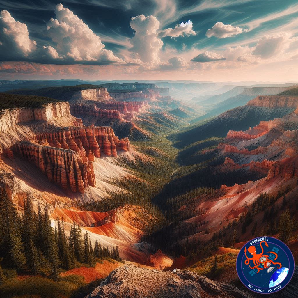
A Natural Amphitheater Written in Stone
High on the Markagunt Plateau in southern Utah, Cedar Breaks National Monument opens like a colossal stone amphitheater carved by time itself. From the rim, visitors stare into a surreal basin of spires, cliffs, and multicolored layers that look almost unreal. From space, the same formation tells an even larger story—one that stretches back tens of millions of years and captures the slow violence of erosion, tectonic uplift, ancient lakes, and volcanic fire. This is not just scenery; it is a readable archive of Earth’s deep past, frozen in rock and shadow.
A View Captured From Orbit
On June 18, 2025, Landsat 9’s Operational Land Imager-2 recorded a striking satellite view of Cedar Breaks. The image reveals a near-perfect semicircular rim, sharply incised drainages, and countless channels radiating outward. These scars mark the persistent work of water, especially Ashdown Creek and its tributaries, which—alongside relentless weathering—have gnawed into the plateau for millions of years. From orbit, the monument appears less like a static landmark and more like an active process still unfolding.
Layers Born From an Ancient Lake
The dramatic formations inside the amphitheater are built from sedimentary rock deposited roughly 50 to 25 million years ago. During that period, this region was home to Lake Claron, a vast and sometimes deep body of water that repeatedly expanded and vanished. Many of the limestone layers visible today began as fine carbonate-rich muds that settled quietly on the lakebed, accumulating grain by grain over immense spans of time.
Why the Rocks Wear Different Colors
The vivid whites, grays, reds, and oranges that stripe Cedar Breaks are not random. They record shifting environmental conditions during deposition. When Lake Claron was deep and wet, iron in the sediments had little exposure to oxygen, preventing oxidation and leaving pale, light-colored layers. During drier periods, exposed sediments allowed iron to oxidize, creating rust-rich minerals that stained the rock in warm reds and oranges. Each color band is a chemical fingerprint of ancient climate swings.
The Grand Staircase Lifted Skyward
After these sediments settled and hardened, tectonic forces slowly lifted them thousands of feet upward. Cedar Breaks now sits at the very top of the Grand Staircase, a massive sequence of sedimentary layers that steps downward through Bryce Canyon, Grand Staircase-Escalante, Zion Canyon, and ultimately the Grand Canyon. In this sequence, the youngest rocks lie at the top and the oldest at the bottom, making the region one of the clearest geological timelines on the planet.
A Monument Above the Clouds
The rim of Cedar Breaks rises to nearly 10,000 feet above sea level—about 7,000 feet higher than the Colorado River far below in the Grand Canyon. This elevation shapes everything. Weather is harsh and unpredictable, winters are long and severe, and snow dominates much of the year. Nearby Brian Head routinely receives around 30 feet of snowfall annually, making this one of Utah’s snowiest regions.
Life Thriving in Harsh Conditions
Despite the brutal climate, life has adapted in remarkable ways. Along the rim grow ancient bristlecone pines, some more than 1,700 years old. Their slow growth produces exceptionally dense wood, which resists insects and disease. Growing on thin soils and bare limestone outcrops, these trees also avoid the wildfires that sweep through lower forests. What appears to be an ecological disadvantage—cold, wind, and poor soil—has become their greatest protection.
Traces of Fire on the Plateau
Cedar Breaks is not shaped by sediment and water alone. Dark basaltic lava flows east of the amphitheater reveal a more recent volcanic chapter. Between 5 million years ago and as recently as 10,000 years ago, volcanoes on the Markagunt Plateau erupted repeatedly, spilling lava across the landscape. Near Brian Head, soft gray rock formed from pyroclastic flows—violent clouds of ash and debris that settled as tuff, later becoming part of the region’s complex geology.
What Undercode Say: Reading Earth’s Memory From Orbit
Cedar Breaks is a reminder that landscapes are not static—they are slow narratives written in pressure, chemistry, and time. Satellite imagery like that from Landsat 9 does more than provide breathtaking views; it allows scientists to read patterns invisible from the ground. Drainage networks expose erosion rates, color variations hint at mineral composition, and lava flows reveal the boundaries of ancient eruptions.
From an analytical perspective, Cedar Breaks stands out because it compresses multiple geological processes into one visible frame. Sedimentation, climate fluctuation, tectonic uplift, erosion, and volcanism all intersect here. Few places show such clarity in vertical storytelling, where elevation itself represents age. The Grand Staircase concept transforms geography into a chronological ladder, making Cedar Breaks not just a destination, but a reference point for understanding the American Southwest as a whole.
The monument also highlights how extreme environments preserve history. High elevation slows biological disruption, allowing ancient trees and exposed rock layers to survive relatively undisturbed. In a warming world, monitoring such regions from space becomes critical. Changes in snowpack, vegetation stress, or erosion patterns could signal broader environmental shifts long before they are obvious on the ground.
Ultimately, Cedar Breaks illustrates why Earth observation matters. Satellites turn remote beauty into measurable data, and spectacular scenery into scientific evidence. The amphitheater is not merely a natural wonder—it is a living archive, still being edited by wind, water, and gravity.
Fact Checker Results
✅ Geological timelines and Lake Claron history align with established scientific research.
✅ Elevation, snowfall, and ecological details match National Park Service data.
❌ No evidence suggests volcanic activity is currently active in the immediate area.
Prediction
🔮 Continued satellite monitoring will reveal subtle erosion and climate-driven changes at Cedar Breaks over the next decades.
🔮 Increased snowfall variability may begin to affect bristlecone pine growth patterns.
🔮 Cedar Breaks will gain growing attention as a key reference site for long-term geological observation.
🕵️📝✔️Let’s dive deep and fact‑check.
References:
Reported By: science.nasa.gov
Extra Source Hub (Possible Sources for article):
https://www.quora.com
Wikipedia
OpenAi & Undercode AI
Image Source:
Unsplash
Undercode AI DI v2
Bing
🔐JOIN OUR CYBER WORLD [ CVE News • HackMonitor • UndercodeNews ]
📢 Follow UndercodeNews & Stay Tuned:
𝕏 formerly Twitter 🐦 | @ Threads | 🔗 Linkedin | 🦋BlueSky | 🐘Mastodon


